


Garmin Navionics+ Vision+ NVUS006R U.S. South microSD
Customize
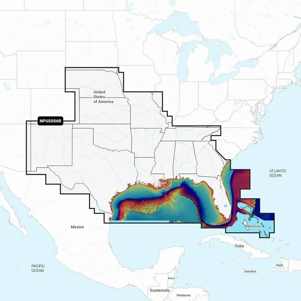
Garmin Navionics Vision+ NVUS006R U.S. South Get the world’s No. 1 choice in marine mapping — with the best, most up-to-date Navionics+ cartography on your compatible chartplotter. This all-in-one solution offers detail-rich integrated mapping of coastal waters, lakes, rivers, and more for offshore or inland waters. Get SonarChart 1’ (0.5 meters) HD bathymetry maps, advanced features such as dock-to-dock route guidance technology (depending on the chartplotter model), live mapping, and Plotter Sync to provide wireless access to daily updates. The Navionics Chart Installer software also ensures the freshest chart data every time out. Navionics route guidance solutions give you a suggested dock-to-dock path to follow through channels, inlets, marina entrances, and more. (Route guidance is for planning purposes only and does not replace safe navigation operations.) Multiple shading options aid in shallow water navigation and make it easy to highlight a target depth range for the best fishing spots. Features include integrated Garmin and Navionics content for exceptional coverage and clarity; easy access to daily chart updates via Navionics Chart Installer or wirelessly via Plotter Sync with the Navionics Boating app; SonarChart HD bathymetry maps (1’/0.5 m contours); Fishing Range advanced feature; shallow water shading; SonarChart Live mapping to create personal HD bathymetry maps in real time; community edits layer; high-resolution satellite imagery and 3D Mariner Eye View where supported. Worldwide coverage available on microSD cards; cartography updates available via annual renewable subscription (first year included). Compatible with compatible Garmin Echomap, GPSmap and other supported chartplotters as listed by Garmin.
- Enhances boating and fishing experiences with accurate and up-to-date data.
- MicroSD format for easy installation and compatibility with Garmin devices.
- Navionics+ feature includes SonarChart and Community Edits.
- Provides navigation aids, depth contours, and other valuable information.
- Detailed and comprehensive marine charts for the U.S. South region.
Specifications:
| Materials & Construction | |
| Included Components | microSD card |
| Product Details | |
| Audio Output Mode | Monaural or Stereo |
| Connectivity Technology | USB |
| Included Components | microSD card |
| Map Type | Marine |
| Model Name | NVUS006R |
| Mounting Type | Panel Mount or Dashboard Mount |
| Special Feature | SonarChart, Community Edits, Dock-to-dock route guidance technology, Daily chart updates, Fishing Range Advanced Feature, Shallow Water Shading, SonarChart Live Mapping, High-Resolution Satellite Imagery, 3D Mariner Eye View See more |
| Sport | Boating |
| Sizing & Dimensions | |
| Height | 20 inches |
| Length | 20 inches |
| Product Dimensions | 20 x 20 x 20 inches |
| Size | 20 x 20 x 20 inches |
| Weight | 2.47 ounces |
| Width | 20 inches |
| Technical Specifications | |
| Connectivity Technology | USB |
| Mounting Type | Panel Mount or Dashboard Mount |