


Navionics Platinum+ NPUS008R - U.S. West
Customize
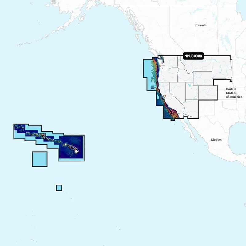
NPUS008R - U.S. West Get the world’s No. 1 choice in marine mapping - with the best, most up-to-date Navionics Platinum+ cartography on your compatible chartplotter. For offshore or inland waters, this all-in-one solution offers detail-rich integrated mapping of coastal waters, lakes, rivers and more. Get SonarChart 1' (0.5 meter) HD bathymetry maps, advanced features such as dock-to-dock route guidance technology, live mapping and Plotter Sync to provide wireless access to daily updates. The Navionics Chart Installer software also ensures the freshest chart data every time out. Navionics dock-to-dock route guidance solutions give you a suggested path to follow through channels, inlets, marina entrances and more. Multiple shading options aid in shallow water navigation and make it easy to highlight a target depth range for the best fishing spots. Navionics Platinum+ charts include all the content of Navionics + cartography, with integrated offshore and inland mapping, 42,000+ lakes and additional viewing options for relief shading, satellite imagery with SonarChart shading overlay, 3D perspective view, aerial photos, and more. Chart Code - NPUS008R Coverage Area: Coverage of the lakes, rivers and coasts of Arizona, California, Colorado, Idaho, Montana, Nevada, North Dakota, Oregon, South Dakota, Utah, Washington, and Wyoming, Hawaii, and the Johnston and Palmyra Atolls. Features: Nautical Chart – Comprehensive charts are derived from multiple official, government, and private sources, displayed in a familiar look and feel. SonarChart HD Bathymetry - Innovative 1' (0.5 m) bathymetry charts created by augmenting existing content with sonar data contributed by the boating community. Community Edits - Get useful local knowledge from edits made by users of the Navionics Boating app. Daily Updates - Up to 5,000 daily updates to our charts. Dock-to-dock Route Guidance - Start your trip with a suggested path. SonarChart Live Mapping Feature - Watch new HD depth maps develop in real-time as your boat moves through the water. Advanced Map Options - Customize your view. Plotter Sync - Transfer routes and markers, update chart layers, and more. Relief Shading, Satellite Imagery with SonarChart Shading Overlay, Sonar Imagery, 3D View and Aerial Photos. Format: MicroSD/SD card. In the Box: SD/MSD Card.
- Great Product
Specifications:
| Materials & Construction | |
| Color | No Color |
| Material | Plastic |
| Outer Material | Plastic |
| Product Details | |
| Included Components | Great Product |
| Model Name | 010-C1371-40 |
| Number of Items | 1 |
| Size | One Size |
| Warranty Description | Warranty |
| Sizing & Dimensions | |
| Height | 1 inches |
| Length | 6 inches |
| Product Dimensions | 6 x 5 x 1 inches |
| Size | One Size |
| Weight | 1.59 ounces |
| Width | 5 inches |
| Technical Specifications | |
| Item Dimensions Lx Wx H | 6 x 5 x 1 inches |
| Item Package Dimensions L x W x H | 5.83 x 4.13 x 0.91 inches |