


Navionics NAUS012R - Canada, East & Great Lakes - Navionics+
Customize
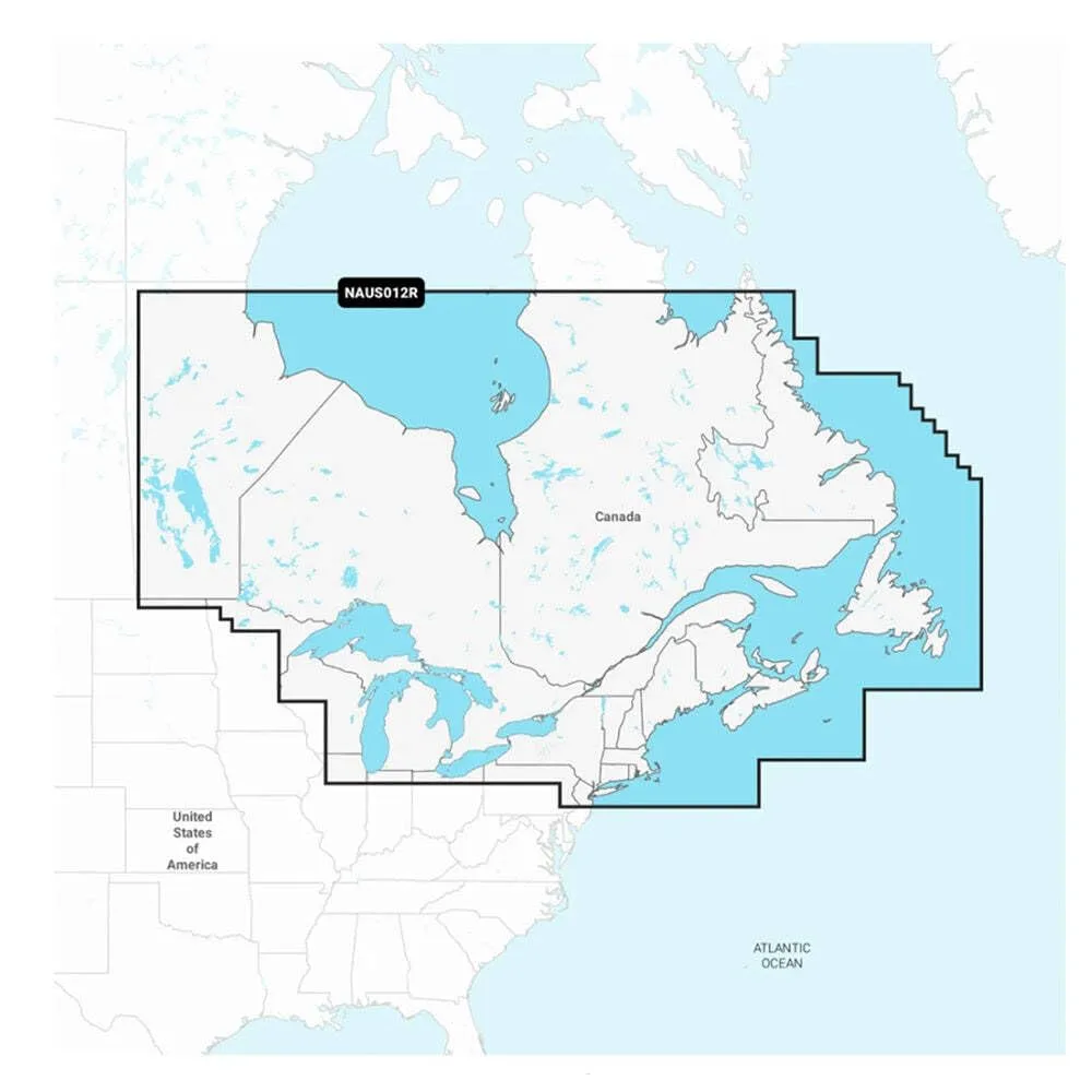
NAUS012R - Canada, East & Great Lakes - Navionics+ Get the world’s No. 1 choice in marine mapping - with the best, most up-to-date Navionics+ cartography on your compatible chartplotter. For offshore or inland waters, this all-in-one solution offers detail-rich integrated mapping of coastal waters, lakes, rivers, and more. Get SonarChart 1’ (0.5 meters) HD bathymetry maps, advanced features such as dock-to-dock route guidance technology, live mapping, and Plotter Sync to provide wireless access to daily updates. The Navionics Chart Installer software also ensures the freshest chart data every time. Navionics dock-to-dock route guidance solutions suggest a path to follow through channels, inlets, marina entrances, and more. Multiple shading options aid in shallow water navigation and make it easy to highlight a target depth range for the best fishing spots. Chart Code: NAUS012R Coverage Area Detailed coverage of coastal and inland waterways of Eastern Canada (except YT and NU). Coverage includes all the Great Lakes, the St Lawrence River, The Maritime Provinces, and the Grand Banks. Features All-In-One Map Solution Access detail-rich mapping of coastal features, lakes, rivers, and more on a wide range of compatible chartplotters. Integrated coastal and inland lake content offers coverage for boaters worldwide. Daily Chart Updates Charts are constantly being enhanced with new and amended content — thousands of updates are made every day. The included 1-year subscription gives you access to daily chart updates via the Navionics chart installer software. Dock-To-Dock Route Guidance Advanced route guidance technology uses boat settings, along with chart data and frequently traveled routes, to calculate a suggested path to follow from dock to dock. Up to 1’ Contours For improved fishing and navigation, up to 1' contours provide a clear depiction of bottom structure for fishing charts as well as enhanced detail in swamps, canals, harbors, marinas, and more. Advanced Map Options Change the way you view Navionics charts to focus on the details that matter most to users. Highlight shallow areas, adjust contour density, or select a fishing range. Community Edits Download community edits for useful local knowledge added by users of the Navionics Boating app, and view the data on a compatible chartplotter. Plotter Sync Transfer routes and markers, update charts, and more between your plotter card and mobile app — wirelessly. Users can even activate or renew their cartography subscription and upload sonar logs. Technical Specifications: Format: microSD /SD. In the Box: microSD /SD. *Sold as an Individual. This product may not be returned to the original point of purchase. Please contact the manufacturer directly with any issues or concerns.
- Great Product
Specifications:
| Materials & Construction | |
| Color | Black |
| Material | Plastic |
| Outer Material | Plastic |
| Product Details | |
| Color | Black |
| Included Components | Great Product |
| Material | Plastic |
| Number of Items | 1 |
| Special Feature | Waterproof, Shakeproof |
| UPC | 821245995896 |
| Warranty | Warranty |
| Sizing & Dimensions | |
| Product Weight | 0.13 Pounds |
| Weight | 2.08 ounces |
| Technical Specifications | |
| Special Feature Detail | Dock-to-Dock Route Guidance; SonarChart 1' HD bathymetry; Plotter Sync; Daily Chart Updates |
| Warranty | Warranty |