


Navionics Garmin 010-C1370-40 U.S. East Platinum+ microSD/SD Card NPUS007R, Black
Customize
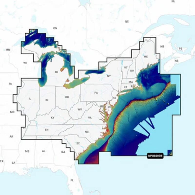
NPUS007R - U.S. East Get the world’s No. 1 choice in marine mapping - with the best, most up-to-date Navionics Platinum+ cartography on your compatible chartplotter. For offshore or inland waters, this all-in-one solution offers detail-rich integrated mapping of coastal waters, lakes, rivers and more. Get SonarChart 1’ (0.5 meter) HD bathymetry maps, advanced features such as dock-to-dock route guidance technology, live mapping and Plotter Sync to provide wireless access to daily updates. The Navionics Chart Installer software also ensures the freshest chart data every time out. Navionics dock-to-dock route guidance solutions give you a suggested path to follow through channels, inlets, marina entrances and more. Multiple shading options aid in shallow water navigation and make it easy to highlight a target depth range for the best fishing spots. Navionics Platinum+ charts include all the content of Navionics + cartography, with integrated offshore and inland mapping, 42,000+ lakes and additional viewing options for relief shading, satellite imagery with SonarChart shading overlay, 3D perspective view, aerial photos, and more. Chart Code - NPUS007R Coverage Area: Coverage of the lakes, rivers and coasts of Connecticut, Delaware, Illinois, Indiana, Kentucky, Maine, Maryland, Massachusetts, Michigan, New Hampshire, New Jersey, New York, North Carolina, Ohio, Pennsylvania, Rhode Island, South Carolina, Tennessee, Vermont, Virginia and West Virginia. Features include Nautical Chart, SonarChart HD Bathymetry, Community Edits, Daily Updates, Dock-to-dock Route Guidance, SonarChart Live Mapping Feature, Advanced Map Options, Plotter Sync, Relief Shading, Satellite Imagery with SonarChart Shading Overlay, Sonar Imagery, 3D View and Aerial Photos. Format: MicroSD/SD card. In the Box: SD/MSD Card.
- Select up to 10 color-shaded target depth ranges to scope out the best fishing spots
- Auto Guidance+ technology lets you navigate with suggested dock-to-dock routings
- With your included one-year subscription, access daily updates via the ActiveCaptain smart-device app
- Customize your view with various chart layers and overlay combinations
- Navigate with our best offshore and inland lake coverage for your Garmin chartplotter
- Made in the USA
- Plastic
Specifications:
| Materials & Construction | |
| Color | Black |
| Material | Plastic |
| Product Details | |
| Connectivity Technology | USB |
| Included Components | Navionics Garmin 010-C1370-40 U.S. East Platinum+ microSD/SD Card NPUS007R, Black |
| Map Type | North America |
| Model Name | NPUS007R - U.S. East |
| Mounting Type | Dashboard Mount, Panel Mount |
| Screen Size | 25 |
| Size | Standard |
| Sport | Fishing |
| Warranty Description | Warranty |
| Sizing & Dimensions | |
| Height | 1 inches |
| Item Dimensions Lx Wx H | 6 x 4 x 1 inches |
| Item Package Dimensions L x W x H | 5.75 x 4.21 x 0.91 inches |
| Length | 6 inches |
| Weight | 2.82 ounces |
| Width | 4 inches |
| Technical Specifications | |
| Model Name | NPUS007R - U.S. East |
| Special Feature | Satellite Imagery with SonarChart Shading Overlay, Sonar Imagery, 3D View, SonarChart Live Mapping Feature, Dock-to-dock Route Guidance, Relief Shading, Aerial Photos |